Home Blog Page 2211

Pioneer photographer Evelyn J. Cameron, one of immigrant ‘women brave enough, sturdy enough’ to live on Montana’s frontier

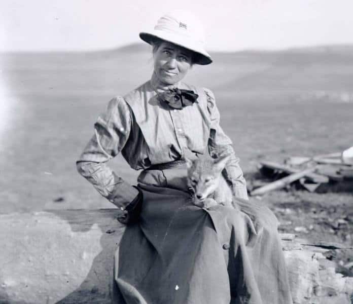
Photographer Evelyn J. Cameron with wolf pup. (Montana Historical Society)

 Evelyn Jephson Cameron was among the thousands of women who immigrated from Europe in the closing years of the 19th century to help ‘homestead’ the West.

It is written that she gave up a life of wealth and privilege in England when, in her mid-20s, she moved with her husband, British ornithologist Ewen Cameron, to America’s frontier in eastern Montana.

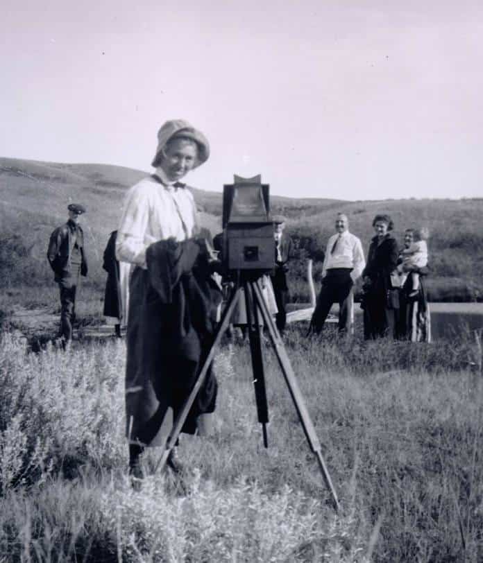
Evelyn J Cameron with “Lexie” her favorite camera.

“Evelyn Cameron thrived in two vastly different social strata. A story of surrendered privilege and of hardships known only to those women brave enough, sturdy enough to live on the Montana frontier of the late 1800’s and early 1900’s,” according to the Evelyn Cameron Heritage website.

“The story tells of an amazing woman who befriended wild animals such as coyotes, antelope and wolves. Finally, it’s the story of the birth and evolution of a great American artist – born in the most unlikely place imaginable.”

“She preferred not having servants and reveled in doing her own housework, gardening, and ranch tending. When Ewen and Evelyn’s attempt to raise polo ponies failed miserably, Evelyn took to photography as a way to earn a living. From her photographs, it is obvious that she admired the ingenuity and propensity for hard work that characterized the Montana pioneer” (Lucey, xvi).

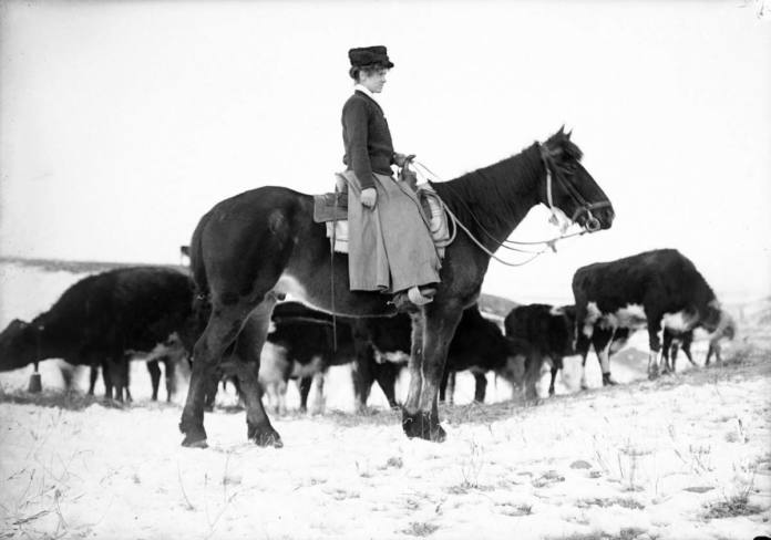
Cameron photographs her friend, Janet Williams, tending cattle.

Her 35 years of diaries recorded daily life in Prairie County from 1894 until her death at the age of 60 in 1928.

Her written words and thousands of black-and-white photographs (taken and processed under crude conditions) detailed life on the high prairie of Montana at the turn of the 20th century.

According to Montana Public Broadcasting, Cameron “photographed the changing face of Montana horse and cattle drives, sheep herding, the wool trade, the railroad, and the arrival of homesteaders.”

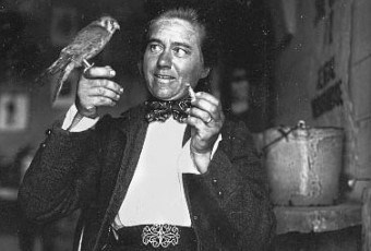
Evelyn Cameron feeding a sparrow hawk (first published in 1908)

Cameron personified the strength and perseverance of early pioneer women. She thrived in the area’s rugged beauty and the freedom life on the prairie afforded her as a woman. It was where women and men worked side-by-side to survive under rough and challenging circumstances.

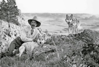
Ornithologist Ewen Cameron with pet wolves, Tussa & Weecharpee.

Cameron would document everything from weddings to immigrant sheep shearing crews, to technological milestones. “To take her pictures, she often rode horseback for 50 miles or more and frequently climbed precipitous mountains on foot with her heavy camera equipment strapped to her back.”

A witness to the end of the open range and the height of the railroad, Cameron’s view of the prairie is one that should not be missed. You can view hundreds of her photographs at the Evelyn Cameron Heritage in Terry, Montana.

If you go

Evelyn Cameron Heritage, 212 Laundre Ave., Terry, Montana. (406) 635-4966.

– Information about: Terry, Montana

Prairie County Fair — Aug.5-7, 2016

More information on Evelyn Jephson Cameron
“Evelyn Cameron : Montana’s frontier photographer,” by Kristi Hager, (2007).

“Meetings with Mrs. Collins: Sketches of life and events on Montana’s open range; from the diaries of frontier photographer Evelyn Cameron, 1893-1907,” by Colleen Elizabeth Carter, (2008).

– “Evelyn Cameron: Pictures from a Worthy Life” first aired on PBS, Sunday, March 1, 2009. Written, directed, filmed and produced by John Twiggs, KUFM-TV/MontanaPBS.

Julianne G. Crane
To read more about the RV lifestyle, go to RVWheelLife.com

(Photo Source: Montana Historical Society. Click on images to enlarge.)

Spin and Win Contest Headquarters

Welcome to our
Spin and Win Giveaway!

A new giveaway is posted every Saturday and runs for three days.

The rules are simple:

•You may enter once a day per household.
•Enter by responding to one or both tasks. If you answer the first one correctly, you will earn five chances to win. The second task earns you one entry point or one chance to win.
You may choose to perform just one both the tasks offered per day in a particular giveaway.

•If you answer a knowledge question incorrectly you will disqualified if you are selected as the winner.

•If you attempt to enter the contest twice in any one day, you will be disqualified.

•Return every day of the giveway to increase your chances of winning. But, remember, just one entry per day per household.

•Prizes may only be sent to addresses with a U.S. Zip Code.

•No purchase is necessary.

•Winner will be notified by email after his or her name is chosen randomly from all entries and will have 12 hours to confirm with a mailing address for the prize and a phone number. If we do not hear from the winner within 12 hours, he/she will be disqualified and another winner will be selected with the same action required to claim the prize. We will continue three times until we have a winner. If no winner responds, the giveaway ends and the prize saved for another day.  

a Rafflecopter giveaway

New National Monuments — see the largest, Mojave Trails

Of the three newly created national monuments, the largest is the Mojave Trails National Monument. Chances are you may have already driven through part of the new monument – that is if you’ve retraced part of America’s “Mother Road,” Route 66. Considered to be America’s most famous highway, a chunk of Route 66 runs through the monument.

Describing the layout – start at the Nevada-California border and fly west 140 miles. The endpoint puts you in Barstow. Overall, you’re looking at more than a million and a half acres of land, highly diverse. From sand dunes to lava flows, toss in a few amazing mountain ranges, and plenty of brush, you’ve got a partial descriptor of this new American attraction.

What might attract you for a visit?

  • Wildlife: Bighorn sheep are rife in the Cady Mountains. 
  • A big hole: Amboy Crater, a volcanic cinder cone around 80,000 years old, containing a lava lake. Back in the heyday of Route 66, thousands of folks climbed it so they could say they’d visited a “real volcano.” 
  • Old fossils: Think you’re ancient? Try being a Cambrian trilobite – a small marine crustacean resembling a horseshoe crab. At 550 million years old, these denizens of the Marble Mountains Fossil Beds now live inside a national monument. 
  • Colorful canyons: Rockwalls in glorious Technicolor, complete with ever-changing lighting makes for amazing photo-ops. Catch this at Afton Canyon. 

Camping opportunities? Yes indeed. Where the trail is open, if not otherwise posted against, you’re free to boondock in the monument.

Check back next time for our final installment on the three new National Monuments.

Photos: Route 66 — Dave Johnson on wikimedia.org. Bighorn Sheep — Magnus Kjaergaard on wikimedia.org. Amboy Crater — Bureau of Land Management. Trilobite — public domain photo.

New national monuments — here’s the scoop on the first of three — Castle Mountains

Castle Mountains, David Lamfrom, wikimedia.org

For some folks, their first knowledge of Devils Tower was the ancient sci-fi film Close Encounters of the Third Kind. That spot in Wyoming became the locust of activities between us earthlings and visitors from outer space. Devils Tower was the first of the nation’s 120 national monuments – can you name the most recent three?

California lays claim to having its own “close encounter” with the three, because all of them are located in the Golden State, and all of them received their designation in February when President Obama granted status to Castle Mountains National Monument, Mojave Trails National Monument, and Sand to Snow National Monument. RVers may be very much interested in these three new monuments – and what recreational opportunities they provide – and will yet provide in the future.

There’s a lot of ground to cover with three monuments, so in this first installment, we’ll cover the northern-most tract of land, Castle Mountains National Monument

whitehouse.gov

A good chunk of this new monument’s 21,000 acres lies in northeastern San Bernardino County, between I-15 and I-40, northwest of the Colorado River. It’s a dry county, stifling hot in summer but attractive in late fall through mid-spring. Castle Mountains is a land of forests of Joshua Trees and solitary dwelling desert creatures.

Don’t mistake Castle Mountains with a national park, where paved roads and visitor centers are standard features. The only roads in the monument are dirt, and they’re of the kind that would like to eat your rig when the rains turn the surface into mud, so plan your trip carefully. There is a visitor center, however, that reaches deep into the natural and human history of the monument, near Essex at 90942 Kelso Cima Road. Spot it on your map 18 miles north of Interstate 40 and some 34 miles south of Baker.

Hole-in-the-Wall, NPS

Camping? Yes, both for the hardy, and the fainter of heart. For boondockers, you can do plenty of roadside camping unless otherwise posted as a no-no. If you prefer a more developed place to park your rig for the night, the National Park Service provides two campgrounds. Hole-in-the-Wall Campground has 35 sites that can accommodate RVs, but be self-contained, there are no utilities, unless you count pit toilets. But there is a dump station and available potable water in the campground. At the 4,400 foot level, you’ll find the place most-loved in October and November, and again in March and April.

The other campground is Mid Hills Campground. At a much higher elevation, this little tiny spot offers cooler nights, but monument officials suggest you don’t try accessing it with a motorhome or travel trailer. Could be great for truck camper enthusiasts, but we recommend other RVers scout it out with the toad car before trying to take a rig up.

And one more caveat – don’t trust your GPS, at least not for showing you reliable roadways. Monument staff say that many GPS databases are NOT up-to-date with the existing road and trail system, and while you’ll know where you are in terms of latitude and longitude, the order of the day could be, “You can’t get here from there.” Carry those old fashioned paper maps to be sure.

Sedona: awesome views, special places

Sedona, Arizona, is Red Rock Country (Source: VisitSedona.com) 
There is a special uniqueness about Sedona. It’s partly the natural beauty in this Red Rock Country and the pull of the majestic mountains–whatever it is, there is definitely a magical essence here. It is said that ancient winds blow rose-colored sand grains into the surrounding mesas sculpting magnificent monuments of timeless crimson beauty.

Tlaquepaque Arts & Crafts Village.

People come to Sedona “to heal and be healed, to express creativity and be inspired.” Among those lured here over the years have been thousands of fine artists, poets, musicians and writers.

Visitors can experience some of today’s artists’ work at the Tlaquepaque Arts & Crafts Village with more than 40 shops and art galleries.  A Sedona landmark since the 1970’s, Tlaquepaque was originally conceived as an artist community. These days people frequently have an opportunity to meet well-known visual and performing artists at Tlaquepaque. To learn about mostly-free events, including First Fridays Evening at the Galleries,  click here.

Chapel of the Holy Cross

The Chapel of the Holy Cross is nestled in the Red Rocks above Sedona. This amazing architectural feat is well worth a visit. There is no charge.

The Chapel rises out of a 250-foot-high twin pinnacle spur, and offers stunning views of the surrounding area. Inside the sweeping views continue through giant glass windows beyond the alter.

Hours: daily from 9-5, and on Sunday from 10-5.
Location:  At the end of Chapel Road, off of AZ Hwy 179.
There is limited free parking at the base of the hill (larger rigs, or pull trailers are not encouraged). From the parking area there is a short, but steep, hike up to the Chapel. A courtesy cart, at no charge, is available for those who need a lift.

Sedona Community Farmers Market happens every Friday, May 27 through October.

Meet the local growers and taste farm fresh fruits and vegetables, eggs, grass fed beef, goat products, tamales, breads and pastries, gluten free, vegan, hand-made chocolates, and live music.

Hours: Friday from 8-11:30 am.
Location: Tlaquepaque Creek Side Parking Lot, 336 State Route 179, Sedona, AZ 86336

Slide Rock State Park (Arizona State Parks)

Slide Rock State Park a public park for outdoor play.

The sun shines an average of over 300 days of the year in Sedona. That’s more sunshine than Florida. Arizona has more National Parks and National Monuments than any other state and Sedona is centrally located near most of them, including Slide Rock State Park, located in Oak Creek Canyon seven miles north of Sedona.

This day-use public park features a smooth natural water slide that cascades into a swimming hole, wildlife viewing, picnic areas and short hiking trails. To read about other nearby state parks, click here.


Entrance Fees: Monday-Sunday: $10 per vehicle
Hours:
Feb 1-Oct 31 – 8 am to 6 pm (last entry 5:30 pm.)
Nov 1-Jan 31 – 9 am to 5 pm (last entry 4:30 pm.)

Free Visitor Information:
Sedona Net 
Click on this spot to connect with a comprehensive calendar of events, many free or low cost, including a film festival, open mic night and quilters’ demos.

Visit Sedona – 
“Want to know where to eat? Where to shop? Where to stay? Curious about special events? Sedona’s unique history? Or would you like to view a map of our most famous hiking trails?” Obtain information from this free Sedona Visitors Guide. Order a glossy guide, or view it online for free.

Sedona’s Best –
If you’re looking for fun things to do in Sedona, Az, and are here on a vacation or visiting, there are many Sedona events and attractions.

Read a previous item on “Vineyard hopping near Jerome, Arizona” elsewhere in RV Short Stops.

Julianne G. Crane 
Read about the RV lifestyle at RVWheelLife.com

‘Nellie E Saloon’ – aka the Desert Bar – near Parker, Ariz., worth a side trip

The ‘ Nellie E Saloon’ (aka Desert Bar) is five miles down a windy, rocky and dusty dirt road and definitely worth the bumpy effort to get there.

This fine piece of history sits in the Buckskin Mountains, north of Parker, Arizona, on land that was
an old mining camp.
The bar was first opened in 1983, in a temporary three-sided structure. It lasted for five years until the current saloon was constructed. The name “Nellie E” originates from the old mining claim where prospectors mined copper and then took it to a smelter and hopefully got gold.

These days the ‘gold’ comes from the hundreds of people that make their way each weekend to this solar-powered oasis.

If you value your RV, do not take it down this road. Besides, there is no room to park it at the Nellie E. When we were there we saw one truck/camper. We drove our 4-wheel drive pickup.

Each Saturday and Sunday, October through April, depending on the weather there is live entertainment from 1-5 p.m. The Cell Phone Cowboys were performing the Saturday we made the five mile adventure on Cienega Springs Road.

Information updated 2016:


Nellie E Saloon / The Desert Bar
Hours: Open October  through April, Saturdays and Sundays only from high noon – 6 p.m., Arizona time,  and holidays during these months.
The bar is closed during the hot summer months.

Refreshments: There is simple food for reasonable prices. We had a passable hamburger for $3. Both hard and soft drinks are available. Full bar.  Families welcome. Bring cash, no credit cards accepted.
Url: www.thedesertbar.com
Directions: 5 miles north of Parker, Az. on Hwy 95. Take Cienega Springs Rd. east 5 miles, follow the traffic. The road ends at Nellie E’s.

Buckskin Mountain Desert Dash — Each year during the President’s Day weekend, the Nellie E Saloon hosts the annual
“Desert Dash,” a 5-mile walk, run or mountain bike trip out to the solar powered bar.
Registration area — On Feb. 13, 2016 at Hwy 95 and Cienega Springs Rd., between 8-9:45 a.m.
$25 day of race.
The “Dash” begins at 10 a.m.
For more information telephone (928) 669-2174 or (928) 667-2829. For additional information on the “Dash” and other local fun happenings go to Parker Area Tourism.

Julianne G. Crane 
Read about the RV lifestyle at RVWheelLife.com

Photos: Top: View from the terrace of The Desert Bar (solar panels line just about every roof-top space). Middle: ‘Cell Phone Cowboys’. Bottom: 1927 Oldsmobile, slightly rusted. (Julianne G. Crane)

Lake Havasu City, Arizona, offers RV snowbirds free sun, low cost fun

When you’re finished boondocking and shopping at Quartzsite and are looking for the next stop on your Snowbird circuit, check out Lake Havasu City on the Colorado River, 75 miles north on Arizona Hwy. 95.

Long a popular year-round tourist destination for folks from Southern California, this thriving community offers many activities for winter visitors. Here are a few for the RVing snowbird:

2nd Annual Lake Havasu Vintage Trailer Campout

See campers like a 1950s Shasta trailer (Julianne G. Crane)

– Feb. 4-7, 2016, beginning at 11 a.m.

The Campout will be showcasing dozens of vintage trailers for everyone to check out.
“We love to have the public stop by and see us.” says event host Cherri Aiken. “When the open signs are out,” people are invited to look inside these vintage rigs.


Details:
– Lake Havasu State Park (Windsor Beach)
– Costs: No event fee, however visitors must pay Park Entry Fees: Per Vehicle (1-4 Adults): $15 on Fridays, Saturdays, Sundays and State Holidays; $10 other days. Individual/Bicycle: $3. Over-Size Parking: $10
– Hosts: Cherri and Mike Aiken; email: jra@cnw.com

London Bridge Model Boat Club’s Annual Remote Control Boat Race

Remote control boat racing (Jennifer Denevan)

– Feb. 5-7, 2016

Come on out to the Bridgewater Channel next to the famous London Bridge for the 12th Annual Remote Control Boat Racing event.

“2014’s event was the largest gas RC boat race in the country, and with speeds from 60 – 90 miles per hour, proving this is an event not to be missed. Various classes will be racing an oval course in the Channel.” Drivers from California, Nevada, New Mexico and Arizona are expected to participate.

“This event is free, so bring your lawn chairs and be ready for two days of a flat-out great time,” say event planners. “Best viewing locations will be the island side of the Channel along the walkway and from the London Bridge.
Details:
– Schedule: Friday: Practice from noon-5 p.m. Saturday & Sunday: Racing 8 a.m.-5 p.m.
– Admission: Free
– Website: www.namba19.com
Contact: Darryl Hamilton email: dwhamilton14@gmail.com; (916) 616-4996; (928) 566-1761

27th Annual Western Winter Blast Pyrotechnics Show

– Feb. 11-14 President’s Weekend

“The shimmer and sparkle of the annual winter holiday fireworks show is taking place above scenic SARA Park,” boasts the folks at the Lake Havasu City Convention and Visitors Bureau. “New memories with family and friends will be created as the clear desert sky morphs into a spectacular kaleidoscope of colors in honor of the 27th anniversary of Winter Blast.”

Details
– SARA Park, 1799 Sara Parkway, Lake Havasu City
Price: $5/person/day (12 and under free) + $5/vehicle/day
Schedule: Fireworks start each evening at 5 p.m. and go until 10:30 p.m. nightly, except Sunday (ending at 10 p.m.). The organized show segments are approximately one hour and begin at 7:30 p.m. Thursday-Sunday, with the largest single show being Saturday night. Gates for the show will open at 3 p.m. each day.

– Website: www.westernpyro.org
– Contact: 928-453-3444

31st Annual Lake Havasu Winterfest Street Festival

Winterfest Street Festival (LakeHavasuBlog)

– Feb. 20, 9 a.m.-5 p.m.; Feb. 21, 9 a.m.-4 p.m.

Thousands of visitors and locals will be making their way downtown to the 31st Annual Winterfest on McCulloch Blvd. between Acoma and Smoketree.  Look for easy access to free parking along Swanson and Mesquite Avenues.

Winterfest offers more than 200 vendors from across the United States features products and services. Browse, watch demonstrations and be ready for “two spectacular days of arts, crafts, clothing, jewelry, home decor, tasty street-food, beer garden, and eclectic entertainment.”
Details:
– Contact Information:
– The Havasu Chamber of Commerce
– Jeni Coke or Lacey Blount at (928) 855-4115; email: laceyb@havasuchamber.com

Julianne G. Crane 
–To read more about the RV Lifestyle by Julianne G. Crane and Jimmy Smith, go to RVWheelLife.com

Tire problems? It could be your tire’s valves!

Tire expert Roger Marble of https://RVtireSafety.com explains why a tire’s valves are so important. Bad valves can

Save your RV battery! How to install a battery disconnect switch

0

In this segment of “The RV DIY® Project Video Series” Mark Polk, with RV Education 101, demonstrates how-to install a

Celebrate ‘History in Lights’ during holidays in Goliad, Texas

Goliad Mission Espiritu Santo (Julianne G. Crane)

Mission Espiritu Santo in Goliad State Park, sits on prime grasslands along the San Antonio River in the South Texas Plains.

RVer Jimmy Smith inside chapel. (Julianne G. Crane)

It is a peaceful place to rejoice in the holiday spirit this season by celebrating History in Lights, from 6 to 8 p.m. the month of December.

“Lights and shadows will tell the story of this remarkable site as visitors walk the same path taken by Native Americans and Spanish Franciscans Priests so long ago,” according to park officials.

“More than 250 years ago, Spanish missionaries and soldiers established” this beautiful Franciscan mission. It became the home of the largest ranching operation in Texas in the18th century. The Spanish colonial church and grounds were reconstructed by the Civilian Conservation Corps (CCC) in the 1930s and includes some original artifacts.

There is much to see during this season with the mission compound grounds, the chapel and workshop being open to the public.

Goliad County (click on to enlarge)

If you go

Goliad State Park
Mission Espiritu Santo
Approximately ½ mile south of Goliad on Highway 183. 
108 Park Rd. 6
Goliad, TX 77963
(361) 645-3405

Latitude: 28.644411  Longitude: -97.438718

Hours: 8 a.m. – 8 p.m., daily except for Christmas Day
Admission: $4; Children 12 years and under: Free

The nearby historically interesting Fannin Memorial and the restored Presidio Nuestra Señora de Loreto de La Bahía are featured in another post.

For information on the Goliad State Park campground, click here.

Julianne G. Crane
To read more RV lifestyle articles by Julianne go to RVWheelLife.com

Whooping Cranes and The Big Tree on Texas Gulf Coast

By Julianne G. Crane
While I have seen “bigger” trees, this Coastal Live Oak is pretty darn impressive. It is estimated to be more than 1,000 years old, with a circumference of 35 feet and a crown spread of 90 feet. It stands about 44 feet tall.

RV Jimmy Smith on bicycle, by Texas’ Big Tree. (Julianne G. Crane)

Known locally as “The Big Tree,” it is part of Goose Island State Park in Lamar, Texas, a few miles northeast of Fulton / Rockport on the Texas Gulf Coast.This tree was named the State Champion Coastal Live Oak (Quercus virginiana) in 1969, and is one of the largest in the nation.Each winter we spend time on the Gulf Coast, we visit the tree as part of bicycling around Goose Island State Park.

On thee different bicycle excursions over the years, Jimmy and I have seen the endangered whooping cranes feeding on berries and blue crabs found in the coastal wetlands around Goose Island State Park.

It is said other local wildlife include white-tailed deer, raccoons, armadillos, foxes, squirrels, cottontail rabbits and more than 300 varieties of birds.

Direction:
About 10 miles northeast of Fulton/Rockport on Highway 35. Just north of the Copano Bay bridge, turn east to Goose Bay State Park. The first right will be Park Road 13. This connects with Lamar Beach Road that takes you to the tree. Depending on the time of day or the season, you may encounter deer on the narrow, densely shaded and flowered road.
Free.

Julianne G. Crane
For more RV lifestyle articles by Julianne G. Crane, go to RVWheelLife.com.