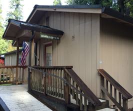
The 2017 Winnebago Paseo Class B motorhome is the first in its class to be built on a Ford Transit Van chassis. It features a spacious floor plan with an expansive rear dinette that converts to a 53 x 72-inch sleeping surface, equipped for cross-coach and longitudinal sleeping. The gas engine gets about 15 miles per gallon.
Inside, it features an all-electric residential-type refrigerator that uses less energy than a 40-watt lightbulb. Its plumbing and water tank are enclosed, helping enable all-weather use. The coach sports a very cool collapsible two-bike rack on the rear. One feature we’ve never seen before is a roof ladder than can be easily moved from the back of the coach to the side for loading cargo to the roof.
Take a tour in this 10-minute video from Winnebago. You can download a brochure at the Winnebago website.
Fleming Sales has released a new 11,000 BTU LP gas grill designed to be used on a tabletop or attached directly to a recreation vehicle.
The RVAD400 Sidekick grill offers 214 square inches of cooking surface and 66 square inch warming surface, and includes grill, bracket, mounting rail and LP adapter. The bracket mounts to the side of most RVs and folds up for easy storage. The grill, when attached to the bracket, converts to a table top stand.
The Sidekick measures 17 inches long, 21 inches wide, 11 inches high, and weighs 27 pounds.
Features:
11,000 BTU single ribbon stainless steel burner
270 sq. in total cooking surface includes a 66 sq. in. warming rack
Comes with an RV mounting bracket that folds up for easy storage
The mounting bracket can convert to a stable base that allows the grill to be used on a flat surface
Includes heavy-duty brass quick-connect adapter to utilize 1-lb. LP gas tanks and use of the grill in other locations
Buried in leaves This is the roof of my motorhome the day we were leaving Eugene. We were parked under a tree for nine days. I figured I’d check the roof before we left. Wow! Yup, there were a lot of leaves. I guess I could have just left them there and let them blow off. I decided to sweep.
The leaves on the small awnings above the the slideout on the driver’s side of the RV were another matter. I wouldn’t want any of those to get dragged inside the RV. So I cleared them off. Many RVs do not have awnings above their slideouts. It seems to me it would be important to sweep off anything before retracting the slide.
If its fall and you’re camped under a tree with leaves, it’s a good idea to sweep off your roof and awnings before you get back on the road.
Truck too small?
This can’t be the truck that pulls this huge fifth wheel trailer, can it? It seems too small to me. The RVer left the park when I was away, so I didn’t get a chance to see him drive away. What do you think?
Rainy Medford We’re in Medford, Oregon, now. We’ll stay a week. When it stops raining we’ll head up to Crater Lake. It’s about a 90-minutes drive. Tomorrow we’re heading to the nearby Oregon Vortex, where things are weird. For example, water runs uphill. I think it’s all trickery. The reason I say that is I saw the same thing as a kid at Knott’s Berry Farm. There’s no Vortex in Anaheim, I’m pretty sure of that. Gail has never been to a Vortex before. So she’s excited. I’ll take a picture of her standing sideways and show it to you later.
One person stands out
This photo was in the Springfield Museum. I snapped a photo because one person really stood out to me. Look for yourself. Does one person sort of jump out at you? I’ll show you a picture down the page of the person I’m talking about. Let me know if you picked the same person. It’s not the woman covering her face; most people are laughing, maybe she’s rubbing her eyes. This was taken at a home appliance show where new devices were being shown.
Twin giants in Medford
That’s Gail in front of the Bunyan Brothers, as they’re called around these parts. The two loggers are made of wood and joined at the shoulder. For the last two decades, minus one year, they’ve greeted visitors to the Jackson County Fair.
The giants were built by Central Point sign maker Hal E. Bishop in the 1950s. The 37-foot characters once advertised the now-defunct Eugene F. Burrill Lumber Co., the county’s last independently run lumber mill.
If you camp at the new Southern Oregon RV Park adjacent to the fairgrounds you’ll see the impressive lumberjack-lookalikes peeking over the pond between you and the fairgrounds.
Oh, did I ever dodge a bullet! Until about two months ago, I lived for about 11 years in a small condo in Edmonds, Washington. It was old, built in the 1960s as apartments, then converted to condos about 25 years ago. There are 77 units in the complex. About five years ago, we were all assessed $8,500 for necessary repairs to the building. Then about six months ago, we had to pay another $3,500. Our condo dues of about $400 a month came up short.
I learned through the years that this sort of thing happens to condo owners. One woman I know who lived in a six-unit condo was forced to pay $50,000 shortly after she moved in due to newly discovered structural damage.
When I sold my condo in July I was aware that another assessment was coming. I knew it would be significant. I figured maybe $10,000, something like that. But, oh my goodness, I learned yesterday that the assessment will be $62,000! The residents may figure out a payment plan, but one way or another, they’ll need to pay it.
I am relieved that I sold at just the right time. But I am terribly sad for my neighbors, most of whom cannot afford this huge hit to their pocketbooks. And I am sad for the woman who bought my unit. She knew an assessment was ahead, but I suspect, like me, she assumed it would be far less.
If I were to ever buy a condo again, I would exhaustively investigate every aspect of it —its structural soundness and the financial position of the owner’s association. I bought my condo, naively figuring it was pretty much like living in an apartment except you owned it. Through the years I learned there’s a whole lot more to it than that.
The person in the picture
This is the person I noticed. To me, he doesn’t belong. Something’s wrong. His head seems too big. Did you guess him, too? If you look at the big photo above you’ll notice that the woman behind him to his right is staring at him. I wonder why.
Learn about RV camping, RV travel, RV news and much more. This newsletter, now in its 16th year of continuous publication, is funded primarily through advertising and voluntary subscription contributions from our readers. Thank you!
Issue 766 • Week of Oct. 29–Nov. 4, 2016
Editor’s corner With Chuck Woodbury Chuck (at) RVtravel.com
My professional writing life came full circle on Tuesday. Gail and I drove our car from our campground in Eugene to Sisters, Oregon, over McKenzie Pass and its giant lava field. Thirty-five years ago I made this same trip on my first road trip in a motorhome — my initial outing as a fledgling roving reporter. One of my first stories was about a woman named Frances O’Brien, who operated an unusual community library in tiny Blue River. I stopped by again Tuesday.
Frances O’BrienThe library today.
For years, Frances had maintained a small library on the porch of her modest home along the McKenzie River. One day in the early ’80s, CBS-TV “on the road” correspondent Charles Kuralt stopped by. Within a few days of his report, books began to arrive by the truckload.
A small addition to her “porch library” had been built in 1975, but after Kuralt’s visit it was much too small. The local Lion’s Club kicked in and helped expand it. When I stopped by years ago there were 40,000 books and hundreds of DVDs. The library was open 24 hours a day with no due date on borrowed books. “All I ask is they return them,” Frances told me at the time.
Frances died in 1992. Today, the Frances O’Brien Memorial Library is open 11-3, six days a week, with an all-volunteer staff. It still operates on the honor system. “If someone doesn’t return a book for a year or two we give them a call,” said volunteer librarian Mary Jo Carroll. But there are no fines.
Even though the library is now several decades old, Mary Jo says many locals still don’t know about it. She said it’s very popular with RVers who vacation nearby in the summer.
Donated books still arrive, but it’s a trickle of what it once was. If you have books or DVDs you would like to donate (be sure to send via Media Mail to save postage), the address is Blue River Library, 51790 McKenzie Highway, Blue River, OR 97413. I noticed some empty shelves, so I know they would be appreciated.
After leaving the library, I wondered where the 35 years went since I visited before. I was reminded that I’ve been “on the road” now for a long, long time.
Oh, almost forgot: Last issue I told you I was heading out to the Oregon coast to see some carnivorous plants. Well, I did. And good news: I did not get eaten! Whew! Read more.
Window advertising in Sisters, Ore., from Oct. 22 Roadside Journal.
THIS WEEK’S CONTEST! UPDATE 10:15 a.m. Saturday: WE HAVE OUR WINNER.Hold your entries.
Win a very cool Cell Phone Portable Battery/Charger— fits in your pocket but powerful enough to fully recharge your iPhone or other smartphone or provide 90 hours more music playback from your cell phone. Be the 41st person to correctly answer this question and you’ll win: “What is the meaning in English of the German word kummerspeck? The answer is below in our Trivia Section. Email your answer to RVcontests (at) gmail.com. We’ll let you know if you win. We can only ship to addresses with a U.S. Zip Code. Only one entry per household. Contest ends Monday at noon (Pacific) if we have no winner.
Last week’s winner: Debbie Mason of Trout Creek, Montana.
RV Parts and Accessories
Give Dyers a try on your next purchase of RV parts or accessories. Large selection, great service, low prices and fast shipping. Visit our website.
Is reading this newsletter worth 10 cents to you? Our staff works hard to bring you a valuable newsletter every Saturday. Readers help make it possible with their voluntary subscriptions. Even a pledge of $5 a year is appreciated — that’s less than 10 cents an issue! Many readers pledge more — $10 a year is less than 20 cents an issue! Your contributions make it possible for us to write about important matters, not just fluff to make advertisers and RV industry big shots happy. Enter a voluntary subscription.Use a credit card, PayPal or mail a check.
Reduce air drag and boost fuel efficiency — Airtab® your RV! Just peel and stick Airtabs™ to the rear sides and the rear roof of your RV coach or trailer to create swirls of air that reduce aerodynamic drag, save fuel and improve stability. Airtabs™ dramatically reduce trailer ‘fish tailing’ and crosswinds pressure to RVs from passing trucks, while improving fuel efficiency 2% – 5%! Click on the video.
What RV do you drive or tow? Send us a photo of your RV (and tow vehicle) with a 150-200 word description of where and how often you travel with it, and what you like or don’t like about it. Include your name(s) and hometown. We’ll post them to RVtravel.com. Send to assistant editor Diane McGovern at Diane(at)RVtravel.com .
CLICK HERE to see the last issue of RV Travel Reader RVs.
RV Armor has tough skin! RV Armor’s tough skin was featured recently in Trailer Life. Read the full story here. RV Armor offers a unique, liquid applied roof system that is Guaranteed for the Life of the RV! No more maintenance, seams, or headaches. Nationwide mobile service. We come to you. To learn more, call 1-855-782-7667 or click here. Click the video to see our 2-day process in 6 minutes!
Got an RV parked at your house? Lock your doors! That’s the admonition from Eugene, Ore., police after a rash of RV burglaries and “uninvited guests.” Several RVs have been burgled, and in some cases the crooks have lived in the rigs — sometimes for days. All the robbed RVs had unlocked doors.
The big RVIA 64th Annual RV Show in Pomona, Calif., that wound up October 16, was indeed big. Stats show that nearly 39,000 attended, up 10 percent from 35,148 last year.
Fees throughout the Los Padres National Forest (Calif.) could increase – as much as double in some cases – if the Forest Service follows through on “farming out” recreation site management to concessionaires. Fifty-two recreation sites may be turned over to Parks Management Company. The government says due to budget cuts it cannot adequately manage the sites. A decision will come soon.
Canadian RV manufacturers are continuing to sing the blues, according to data from Statistical Surveys Inc. August sales of towable units dropped 5 percent compared to August 2015. Travel trailers dropped 3 percent, and fifth wheels were down nearly 13 percent. Popups and park models also declined, the former a mere 7 percent, but the latter a whopping 47 percent.
Don’t try to outrace the 1972 Winnebago Brave motorhome modified by a Canadian company. It has a brand-new, smoking-hot 900 horsepower engine, a far cry from the gutless wonders of the era. The outside looks pretty much like any other 1972 model. But the inside? You have to see it!
RV-owning residents in Whittier, Calif. – an unincorporated part of Los Angeles County – are up in arms with a new law proposed by the local board of supervisors. The ordinance would completely ban parking of RVs on Whittier’s streets. RV parking is already limited to 72 hours; residents could obtain temporary permits to park for short periods of time but would have to drive to Norwalk to get them.
Entegra Coach is recalling certain model year 2017 Cornerstone motorhomes manufactured April 13 to August 25, 2016, that have a power steering pump that may experience an occasional loss of output power resulting in reduced or intermittent loss of power steering assist which could increase the risk of a crash. Owners should contact Entegra at 1-800-945-4787 regarding recall 9903325.
Motorhome club Family Motor Coach Association (FMCA) has a new executive director with some big plans. Chris Smith says plenty of people see the FMCA emblem (“goose egg”) on motorhomes, but few people know what it means. Smith wants more “take notice” of the group, and added, “I want members to feel that the value of their membership far exceeds their annual dues.” To that end Smith gave a hint: “Stay tuned, because we do have some exciting plans in the works.” Source: RVbusiness.com.
A non-profit California group called RVs for Veterans, currently run by Paso Cares, is trying to live up to its name. The San Luis Obispo organization has provided 60 rigs to help out homeless veterans (including families) in the Central California area. Once they find a rig for the veteran, they also help them find a place to put it. There’s a waiting list of 30 homeless vets needing a new home. If you have one to donate or want to help, contact them at Paso Cares or call 805-712-7067.
Winter Differently This Year! When temperatures drop and the snow starts to fall, head south for the Winter! Florida, Arizona and South Texas benefit from beautiful sunny days and gentle warm breezes. You can too! Stay a week, a month, or the whole season! Book your long-term seasonal or annual stay at one of over 80 resorts in the Southern United States. Click here to learn more!
More News
Hot generators? Riverside, Calif., fire and police officials have raised eyebrows after responding to a motorhome fire at a storage facility. The motorhome was completely destroyed and three others damaged. Neighbors told investigators that several generators had been stolen in the area recently. Arson investigators are sniffing around — still no cause listed.
New York’s state parks saw plenty of action this year: Through Columbus day, visitors broke the 2015 record of 623,891 overnight stays over the summer, with 633,000 for the same period this year – the fifth consecutive year of record attendance.
A tip-of-the-hat to Medicine Hat, Alberta, government folk. Gas City Campground there is now closed for revamps to add electrical hookups to some RV sites, as well as other utility improvements. About half of the $200,000 project is being funded by a grant.
This year’s final National Park free entrance day is coming up Friday, November 11. The fee waiver does not apply to camping.
We reported earlier about the charges against the Tacoma, Wash., RV salesman up on a rap of claiming he couldn’t work – but working all the same. Bobby Ray Johnson (48) now has a 45-day jail sentence and $81,000 in restitution to pay after pleading guilty to first-degree theft. Johnson fell on ice while selling rigs in Poulsbo, Wash., in 2013. He filed a Workman’s Compensation Claim, but then went on to work selling RVs at three different dealers for the next two years.
Slammed the outhouse door – that’s apparently what residents of Morden, Manitoba, have done in the eyes of community leaders. After pumping $70,000 into restroom renovations at Lake Minnewasta, a survey of 800 locals gave the new restrooms two out of a possible five. The remodel was prompted by an earlier survey wherein people complained about the same restrooms. “People complain about washrooms all the time,” stated Clare Agnew, Morden community services director. “It doesn’t matter what you do.”
Photo: CBS Philly
A motorhome fire on the Delaware Memorial Bridge (N.J.) took a heavy toll on a marijuana advocacy group, Weed World Candies. Their rig, carrying $50,000 worth of merchandise, including pot-laced lollipops, went up in smoke last Sunday, closing some bridge lanes for three hours. We assume responding firefighters didn’t inhale.
DC’s RV Center in Bakersfield, Calif., has lost its state license to do certain types of work after a lengthy investigation. “We inspected the consumer’s vehicle, and confirmed $4,000, in excess of $4,000, in repairs that were never performed,” said Joseph Blanton of the Bureau of Automotive Repairs after a customer complained. DC’s RV was also ordered to pay restitution of about $45,000 to other victims.
Campsites may be even harder to find next summer than last based on strong RV sales. Wholesale RV shipments made to retailers increased this September by 20.5 percent to 33,704 from 27,960 last year, according to the RVIA. And year to date, shipments increased 13.8 percent to 324,286 from 285,049 in the same nine-month period in 2015.
If the Pope felt left out when 5,000 motorhomes rallied outside the Vatican last weekend, he didn’t have to feel that way for long. Before the annual RV rally was over, Pope Francis was presented with a motorhome of his own, based on a Fiat Ducato. Don’t expect to see him boondocking in Italy soon — the Vatican says the rig will be used in charitable work. This isn’t the first time Fiat has delivered a customized Ducato van to the Papal motor pool. Fiat also gave one to Pope Benedict XVI in 2009 for use in touring parts of the Italian countryside destroyed by a devastating earthquake — coincidentally where the Ducato is built.
Keep up with RV Industry news throughout the week at RVbusiness.com.
Organize your bath with a shower caddy This waterproof hanging shower caddy has 6 durable mesh pockets — 3 generously sized pockets with holes for holding bottles upside down and 3 smaller accessory pockets to store loofahs, bar soaps, razors and more. It has rust-proof grommets and is made of quick-drying breathable mesh — wipe with a damp cloth or wash by hand. Just hang using your existing shower curtain rings or hooks. Great for the RV! Learn more or order.
RV Quick Tips
Help for emptying tanks on a slope
Pull into a dump station with a slope away from the dump? Getting the tanks empty can be difficult — until you crank up your leveling jacks on the far side of the rig to give your sewage a little lift.
Handy, and considerate, night lights
LED “tap” lights near fifth wheel stairs, in the bathroom and other places where a light is needed during the night can keep you from stumbling, or fumbling for light switches. Easier on your partner, too — the low level of light doesn’t disturb sleepers.
Always keep the battery fully charged
Take the batteries out of the rig and store them in the garage over winter? It’s an old-wives’ tale, provided you make sure the battery is kept charged. Use a battery maintainer to ensure the charge. It’s when a battery falls below full charge that you’d need to worry about it freezing.
Do you have a Quick Tip? Send it to Diane (at) RVtravel.com and you just might see it here!
Temperature gun is ‘essential equipment’ for many RVers! Just aim this non-contact IR temperature gun to measure the temperature of your refrigerator, tires, A/C output, or, heck, even your oven (and the list goes on). It turns on and begins reading the temperature in Celsius or Fahrenheit with one press of the trigger. A laser light aids in aiming, and can be turned on or off. Many RVers consider this essential equipment. Learn more or order at a huge discount.
Connect to the Internet from anywhere
“NO SIGNAL” — the words that are the bane of an RVer’s life. Without a connection, there’s no way to talk to friends and family far away. There’s no way to get news, weather, or your checkbook balance. Perhaps worst of all, there’s no way to call for emergency help. But here’s a solution.
“I inspected my tires but still had a failure”
Roger Marble, RV tire expert, read recently on an RV trailer forum of an RVer who checked the air and inspected all four tires before they pulled out. Only 20 miles from the house a tire blew out. The tire service center and RVer checked the remaining three tires and spare, all appeared well, and 15 miles down the road a second tire blew out. Roger offered this possible explanation.
The readers always write …
Fall is decidedly upon us and plenty of folks have already headed “south for the winter.” Others of you may have put the rig “up on blocks.” Regardless of your venue, those computer keyboards and smartphone pads are busily clicking away with commentary on what you’ve read in the last couple of weeks on RVtravel.com. Here are some highlights.
See more through your RV window awnings
RV window awnings typically have two positions — deployed or stowed. When the window awning is deployed it can cut your viewing area in half. But half the fun of RVing is the scenery, isn’t it? Here’s a swift trick to solve the problem.
Lava as far as the eye can see
The Earth threw up lava in the Cascades near present-day Sisters, Oregon. Today, scenic Highway 242 passes through a swath of the 65-square mile, surreal landscape. At the summit, a paved walking trail meanders through a half-mile of the bizarre landscape. If you have never seen a lava flow, be prepared to be amazed! Read more.
The fine art of procrastination — now in “RV flavor”!
Rich “The Wanderman,” like so many other RVers, has projects that he wants to accomplish in addition to projects that he has to accomplish — which means the wants are still “wanting.” Since his RV is winterized, he plans to get to some of the projects he has been putting off. Well, at least that’s his good intention — and we all know about “good intentions,” right? We’ll bet you can relate to this article by Rich.
Endorsed by Roger Marble of RVtireSafety.com! An excellent tire pressure gauge The Accutire MS-4021B digital tire pressure gauge has an easy-to-read LCD display that provides pressure readings from 5-150 PSI. It’s ergonomically designed with an angled head and a rubber-coated easy-grip handle. If you forget to turn it off, it will do so automatically. The included lithium battery never needs to be recharged or replaced. All for less than $13! Learn more or order.
No Shock Zone, Part Six
In this episode, learn about how amperage draw causes voltage drop, which is why your coffee pot can cause the lights to dim in your RV. The information in this 12-part series has saved lives. It’s very important. Take the time to read. If you missed last week’s episode about amperage and ways to calculate how much your RV needs before you plug into a power pedestal, read it here.
Is covering RV tires for even a few days worth the effort?
RVtravel.com editor Chuck Woodbury talks with RV tire expert Roger Marble of RVtireSafety.com about RV tires. In this case, Roger answers the question, “Is covering your RV tires for even a few days worth the effort to save them from exposure to damaging UV waves?” Watch the short video.
Bent motorhome door fazes RVer
Chris Dougherty, certified RV technician, received a question from an RVtravel.com reader when he was serving as our technical editor. The reader explained that the side entrance door on his 2004 Jayco 27DS motorhome was slightly bent and wouldn’t close completely. He wondered if he could bend the door back in place. Read Chris’ answer.
Snag some Burger King loot — cheap!
Fall has to be one of desert-dwellers Russ and Tiña De Maris’ favorite times of the year. Daytime nice, nighttime cool air. Fall leaves. Burger King coupon book specials! Read more.
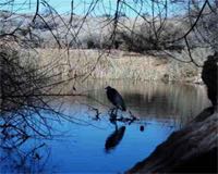
An oasis near Vegas perfect for RV boondocking
The Desert National Wildlife Refuge north of Las Vegas, Nevada, is not somewhere you go to stay in a full hook-up RV resort or to visit Nevada’s famed casinos. But the oasis at the refuge headquarters at Corn Springs is a welcome splash of green along with an abundance of bird and other wildlife species. This 2,200-square-mile refuge is the largest in the lower 48 states. Boondocking with views of looming Mt. Charleston is permitted on the open land surrounding the visitor center. Learn more.
Join the largest club for motorhome owners, the Family Motor Coach Association (FMCA). Special rate for RV Travel readers. Save $10 on first year membership. Click to learn more.
This week in history Week of Oct. 29–Nov. 4 Compiled by Dell Bert
1879 — Will Rogers is born in Oklahoma.
1864 — Helena, Montana, is founded after gold is discovered.
1864 — Nevada becomes 36th state.
1929 — Stock market crashes.
1938 — Orson Welles scares nation with “War of the Worlds.”
1947 — Howard Hughes’ “Spruce Goose” flies for the only time.
1990 — “Dances With Wolves” debuts.
1998 — John Glenn, at 77, returns to space.
Avoid moisture damage to your RV
DampRid FG50T Hi-Capacity Moisture Absorber, 4-Pound Tub eliminates musty odors in RVs and other spaces, protecting them from moisture damage for up to 60 days in areas up to 1000 square feet, and up to 6 months in a 250-square-foot area. Don’t let your rig get damaged from moisture this winter. Learn more or order.
RV Club of the Week Here is an RV club we like. We hope you do, too!
Welcome to a brand-new club:Montana 5th Wheel Rovers Club
Started by 5th wheel owners of the Montana, Mountaineer, High Country and Big Sky — but they are all-inclusive. (Almost 130 members in its first week of existence!) Their forum is very informative, helpful and super friendly. Find out how your RV is constructed, how to boondock using solar panels, what you need to become a full-timer and all aspects of RVing. They have regional rallies and gatherings all around the U.S. “Come and see for yourself.”
Lightweight vacuum perfect for RVs
This Dirt Devil Simpli-Stick Lightweight Bagless Stick Vacuum is compact and it works great. Plus it converts to a hand vacuum in a snap! It’s the vacuum of choice in the RV Travel motorhome. Weighs less than 4 pounds. Learn more or order for about $20.
Bumper sticker of the week Consciousness: That annoying time between naps.
Chuck Woodbury spotted this truck in Springfield, Oregon.
Funny/clever business slogan Thanks to Ralph and Tricia Graner for sending this in: “Every year we laugh at the signs on the beach porta potties when we’re in St. Augustine, Fla. The company is Floaters Portable Sanitation. The slogan posted on all their porta potties: ‘You Float’m – We Tote’m’.”
Have you seen a funny bumper sticker or business slogan? Send it to Diane(at)RVtravel.com
• • •
Upcoming RV Shows See the list of upcoming RV shows for 2016 and 2017.
RV Safety Why a young boy died by simply touching the family RV.
. . . and how to prevent it happening to you or your loved ones. Click.
Multipurpose Microfiber Duster No more car wipes to dry up. This duster replaces all interior car products. The 10-inch dusting head is big enough to get your dash dust-free quickly, but small enough for your glove box. The back doubles as a scrubbing sponge. Great for interior or exterior use on cars, RVs or home! Learn more or order.
Websites of the Week Here are three we like:
Edna and Robert enjoy reading their RV Travel Newsletter every Saturday morning. “It’s the way we start our day,” said Edna. The couple met four years ago on Match.com. They like to camp along the coast, where they enjoy long walks on the beach.
The one thing you must do in every state
No, we’re not going to make you do these things — but you’ll surely want to do them while you’re in the area. This is a list of must-sees and must-dos in each state, and which you may not find anywhere else in the U.S. From cheapism.com and msn.com.
29 hearty fall slow-cooker recipes
These deliciously hearty recipes would be great to make in your slow cooker. How about Beef Bourguignon, Jambalaya, Garlic and Herb Cheesy Chicken Dumplings or another of these tasty dishes awaiting your return to your RV after a day of sightseeing, or when you arrive at your campground after a long day of driving? Mmmmm! From delish.com and msn.com.
50 of the dumbest laws in every state
Can’t eat fried chicken with utensils in Georgia? Pickles must bounce in Connecticut? No cursing while driving in Maryland? (Uh-oh!) No Sasquatch poaching in Washington state? Interesting reading. From Reader’s Digest and msn.com.
Camco Wheel Chocks. Two Pack Wheel chocks are one of those “must have” basic items for all RVers. Hey, who wants to go rolling outta their campsite at 3 a.m.? For trailer owners, the chocks are designed to keep your RV in place so that you can re-hitch with confidence. The chalks are constructed of durable hard plastic with UV inhibitors and are easy to use. Learn more or order.
Good reading from RV123.com
• Cape Cod Campresort is the perfect place to stay while enjoying the historic Cape Cod community.
• Whether you serve it with chips or enjoy it by itself, this recipe is sure to be a campground favorite!
• Found just north of the Ozarks of Arkansas is the Harrison Village Campground and RV Park.
Strengthen your hands, fingers and forearms
Here’s a great, easy way to build up the strength in your hands, fingers or forearms. Perfect for RVers. If you suffer from arthritis, carpal tunnel, tendonitis or tennis elbow this is for you. It’s also great for simply building up the strength of your grip. This is a best seller and costs about $8. Learn more or order.
Ask the RV Shrink
Wife wants to replace broken microwave; hubby says “no”
Dear RV Shrink:
Our microwave just started making a terrible buzzing noise and no longer heats. My wife wants a new one, but we have only used this one a few times. We use it almost exclusively for storing our plastic food containers. I think we should just pull the old one out and build the space into a storage cabinet. She thinks we should spend three hundred dollars for an appliance we use once a year.
Can you give us some input to cease our petty arguing. —Nuked out in Nevada
DON’T RISK HARMING YOUR RV
It’s time to Winterize!
Winter’s coming fast and for many RVers in the USA and Canada that means it’s time to winterize their RVs. Prestone RV Waterline Antifreeze offers burst protection to -50 degrees Fahrenheit, a non-staining dye, and a ready-to-use formula (no need to dilute). Will not harm plastics, except acetate. Learn more or order at a great price.
RV Tech Tips from Mark Polk
Clean your air conditioner filters
Keep the filters in your roof air conditioner clean and it will operate more efficiently. Refer to the A/C owner’s manual for cleaning instructions. Replacement filters are sold at most RV dealerships.
Mark Polk is the owner of RV Education 101, the premiere source of educational DVDs about buying, maintaining and using an RV. Learn more.
Latest fuel prices Here are the latest U.S. average prices per gallon of gasoline and diesel fuel: Regular unleaded gasoline: $2.24 (on Oct. 24). Change from week before: Down 1.4 cents; Change from year before: Up 1.5 cents. Diesel: $2.48 (on Oct. 24). Change from week before: Down 0.3 cent; Change from year before: Down 2 cents.
Be prepared for a roadside emergency! Forget messing around with flares.
You’ll be thankful to have this set of three emergency flashers along with you if you’re forced to the side of a busy highway with a flat tire, mechanical or other issue. One FlareAlert™ provides about 20 hours of safety before a battery change (three AAAs in each). You’d need to strike 80 incendiary flares, one after another, to achieve the same thing.Learn more or order.
RV Travel Reader Pets— Pet of the Week
Do you travel with a pet? We’d love to introduce your pet(s) to fellow readers. Send a photo or two of Fido or Boots and a 150-200 word description of your furry friend(s), along with your name(s) and hometown to Diane(at)RVtravel.com .
From Paul and Debi Pitzer (retired), Rendon, TX Our “furbaby,” Winston (the Pooh) Churchill, or “Winnie,” is a 3.5-pound teacup Schnauzer. He is 13 years old and travels everywhere with us in our motorhome. He has never been boarded and can’t stand to be away from us, especially since our other furbaby, “Tanner,” went to the “Rainbow Bridge” last year. Winnie loves to walk and we don’t let him get too far from us, as a lot of the campgrounds have eagles and wildlife that could endanger him.
“Take the road less traveled.” —Paul, Debi and Winnie
Click here to see the last issue of RV Travel Reader Pets.
Keep your fridge in order when you travel Tired of stuff moving around in your RV fridge after a day of driving? Maybe a carton of milk has fallen out on the floor one too many times? Here’s the solution. Camco’s RV Double Refrigerator Bar is designed to keep order in your RV fridge during travel. It’s spring loaded to keep items in place. The bar extends from 16″ to 28″. And the good part is the price tag: about $5! (The RVtravel.com staff uses a pair of these in its RV!) Learn more or order.
The RV Kitchen with Janet Groene
Tomato Surprise Spice Bread You put WHAT in this bread?
No rising, no electric mixer. Just crank it out and stick it in the oven. Like other quick breads, this one slices better if it’s cooled, wrapped and allowed to equalize for several hours. However, it’s hard to resist it when it’s fresh and warm right out of the oven. The bread is slightly sweet, making it a good accompaniment for ham ‘n bean soup. Get the recipe.
Fix it in Foil! Tasty Recipes. Easy cleanup! Easy prep, great taste, good nutrition, quick clean-up! “Fix it in Foil” includes 51 fantastic recipes to make in foil — plus instructions for cooking in an oven, on an outdoor grill, or on a campfire. Fix it in foil and forget about scrubbing pots and pans. And, with plenty of substitution suggestions, enjoy a whole new list of recipe possibilities! Great for RVing! Learn more or order.
App of the Week
Want to print your photos while traveling?
If you want to get prints of your photos and you don’t want them mailed home when you’re on the road, Walgreens has your answer. It’s an App called “Printicular” and it allows you to select photos from your phone, Google+, Instagram, Facebook, Dropbox, Google Photos or Flickr. They’re very reasonably priced and usually only take about an hour! Read more in this article from Chris Guld of Geeks on Tour about this handy and free app.
The special offer for RV Travel readers is back!
Become a member of Geeks on Tour and get a 20% discount. Click here.
DON’T LET A LOW BRIDGE RIP OFF YOUR ROOF! 2017 Rand McNally Motor Carriers’ Road Atlas If you drive a big RV — extra long or extra tall — then this truck driver’s road atlas will be a huge help in knowing where you can drive without encountering a low bridge or getting stuck hanging over a cliff. This is an essential aid even if you have a GPS! Coverage: United States, Canada, and Mexico. Learn more or order.
Ask the RV Doctor The RV Doctor, Gary Bunzer, answers your questions
Water pump doesn’t pump
Dear Gary,
I’m having my RV winterized for storage. The dealer called to tell me that the pump doesn’t work. It is located underneath the fresh water holding tank. They unhooked it from the tank to pump antifreeze into the pipes and it wouldn’t work. Is it a suction pump? Does it have to be connected to the holding tank to work? —Walter
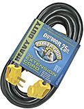
Every RVer with 30-amp service should have this on board Don’t use a wimpy extension cord! Get this! Don’t be caught short when you hook up to power. And don’t use a wimpy extension cord that could get overloaded and damage your appliances or, worse yet, cause a fire. Camco’s RV 25-foot, 10-gauge, STW 30 AMP PowerGrip Electrical Powercord with handle is perfect for RV use. If your coach is wired for 30 amps, you need this. Learn more or order at a big discount.
Save water by preparing meals ahead of time
Since water is one of the limiting factors in boondocking, for your next boondocking trip prepare several meals at home — like lasagna, spaghetti and meat balls, or enchiladas — and freeze in individual freezer-safe plastic bags. At mealtime plop them into a pot of boiling water. After cooking, save the water to reuse, either for cooking the next meal or for flushing the toilet. Save the water you run to warm up your shower to cook with. It is also a great cooking time-saver, when you would rather be doing something else.
Space heater uses only 200 watts! It’s hard to believe that an electric space heater could use a mere 200 watts — the same as a couple of light bulbs —a fraction of other space heaters. And this one really works! It’s meant to heat a nearby person, not a room. Put it on your desk or at your feet. It’s perfect for the RVer who’s “always cold.” For about $17, this is a winner. Click the video by RVtravel.com editor Chuck Woodbury. Or order at Amazon.com.
Gizmos and Gadgets
Opti-Brite LED headlamps: rugged, with stunning engineering
Optronics International, a manufacturer of heavy-duty LED vehicle lighting, has announced its most advanced Opti-Brite LED Headlamps, which emit a wider, brighter beam for increased visibility and safety. They approximate the color temperature of natural sunlight, improving visibility and reducing eye fatigue. The new lamps have an expected service life of 30,000 hours, are aggressively priced and include a lifetime warranty to replace the lamp if even one diode fails. Read more.
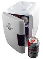
Cooluli introduces portable six-can cooler/warmer
Cooluli introduces a portable six-can AC/DC electric cooler and warmer with USB power cord that fits on a counter or in a vehicle. The thermoelectric system allows for easy switching from beverage cooler to food warmer. Holds up to six 12-ounce cans or four 16-ounce bottles. It works without refrigerants, so it’s environmentally friendly. Learn more.
Easy way to level your RV! The RVtravel.com motorhome packs along two of these and, boy, are they handy! Camco’s RV Yellow Tri-Levelers are designed to raise the RV up to 3-7/8″ on any tire for a more level position. The lightweight levelers are durable and have a resin non-slip surface with a load capacity of 3,500 pounds. Learn more or order for a great price!
Short Stops
The Simpsons’ Home Town Springfield, Oregon
This town next door to Eugene is the home of the TV cartoon series “The Simpsons.” That’s according to cartoon series creator Matt Groening. There isn’t much evidence around town but if you look closely you’ll find some. Just off Main Street, on South 5th, the outside wall of an art shop features a large mural of the fictional family. In the Springfield Museum, large, plastic Simpson caricatures greet visitors, with space for a photo sitting alongside Homer, Marge and the gang. Read more.
Get ready for winter Keep your water flowing in freezing temps with heated hose Camco’s Heated Water Hose provides safe drinking water in freezing temperatures by combining a drinking-water-safe hose with a self-regulating heat source encapsulated in an all-weather, PVC coating. Operates on 120VAC/1.3 AMPs. Made in the USA. Learn more or order at Amazon.
Stupid Statements of Yesteryear
“Stocks have reached what looks like a permanently high plateau.” —Irving Fisher, Professor of Economics, Yale University, 1929 [just before the stock market crash].
Prevent hose crimping and strain . . . and extend RV hose life This 90-Degree Hose Elbow eliminates unnecessary stress and strain on all RV water intake hose fittings. The elbow, with an easy-grip connector, is made of brass and is lead-free. Learn more or order for a great price!
Videos you’ll like
When winterizing RV, should lines be blown out or is RV antifreeze better?
Gary Bunzer answers this question from an RVtravel.com reader. Watch the video.
Keeping your batteries charged when RV is in storage
Mark Polk of RVeducation101.com has some good tips. Watch the video
Random RV Thought When you’re traveling in rural areas and want to use your cell phone or AirCard from your campsite, be sure to visit the actual site where you want to stay — not just in the campground near the office. Service may be spotty. The same goes for using a park’s WiFi.
Keep rodents out of your RV!
The overwhelmingly positive reviews on this make it a best bet for keeping your RV rodent-free. This is the only plant-based rodent repellent registered for inside use by the EPA. It effectively repels rodents up to 100 days with a “woodsy” scent that’s pleasant to humans but offensive to rodents. It’s safe around kids and pets so no safety warning is required. 98% biodegradable. Endorsed by the Good Sam Club. Learn more or order.
Trivia
The German word “kummerspeck” means excess weight gained from emotional eating — literally, “grief bacon” —according to MentalFloss.com.
Help stabilize and keep your RV steps safe The RV Save-A-Step Brace is designed to be placed under RV entry steps for safety. It stabilizes the RV steps and helps keep the coach from rocking — preventing sag and wear. The brace is made of heavy-gauge steel with a 3/4″ solid metal screw thread, 1000-pound load rating and 7-5/8″ to 14″ adjustment range. Learn more or order at Amazon.com.
Worth Pondering “To be ignorant of what occurred before you were born is to remain always a child. For what is the worth of human life, unless it is woven into the life of our ancestors by the records of history.” —Cicero
Happy Anniversary! • November 2: To Jeanette from David. The road of life, 52 years with the ups and downs, what a great ride with the love of my life, and there is so much more to come.
RV Travel staff Editor and Publisher: Chuck Woodbury. Assistant editor: Diane McGovern. Contributing editor: Russ De Maris. Contributing writers: Greg Illes, Bob Difley, Richard Miller, Richard Mallery, Janet Groene, Roger Marble, Julianne Crane and Chris Guld.
RVtravel.com is rated PG* by the Community of Realtors United against Drugs (CRUD)
ADVERTISE on RVtravel.com and/or in this newsletter. Contact Chuck Woodbury at Chuck(at)RVtravel.com.
About the RVtravel.com editor Chuck Woodbury has explored America by RV for nearly three decades. In the ’90s he published the quirky travel newspaper Out West, and was an “on the road” writer for the New York Times Syndicate. His book, “The Best from Out West” is available at Amazon.com. Woodbury’s RVing adventures have been profiled on ABC News, CNN, NBC’s Today Show, and in People Magazine, USA Today and in hundreds of newspapers. Nowadays, he lives near Seattle, where he drinks massive amounts of coffee and travels often in his motorhome and sometimes by plane when vast expanses of saltwater would turn his RV into a leaky submarine. He is the host of the Better Business Bureau DVD “Buying a Recreational Vehicle,” the definitive guide to purchasing an RV the right way.
Everything in this newsletter is true to the best of our knowledge. But we occasionally get something wrong. We’re just human! So don’t go spending $10,000 on something we said was good simply because we said so, or fixing something according to what we suggested (check with your own technician first). Maybe we made a mistake.Tips and/or comments in this newsletter are those of the authors and may not reflect the views of RVtravel.com or this newsletter.
Our offices are located at 610 5th Ave. S, Suite F, Edmonds, WA 98020.
This website utilizes some advertising services. Sometimes we are paid if you click one of those links and purchase a product or service. Regardless of this potential revenue, unless stated otherwise, we only recommend products or services we believe provide value to our readers. Amazon and the Amazon logo are trademarks of Amazon.com, Inc . RVtravel.com is a participant in the Amazon Services LLC Associates Program, an affiliate advertising program designed to provide a means for sites to earn advertising fees by advertising and linking to Amazon.com.
RVtravel.com includes links to other websites. We cannot control the content and/or privacy policies of those sites. Please be aware when you leave this newsletter or any other section of RVtravel.com to read the privacy statements of any of those websites that collect personally identifiable information. Our own privacy policy applies only to RVtravel.com and its affiliated blogs.
This newsletter is copyright 2016 by RVtravel.com
*Pretty good
TODAY’S DEALS ON RV PARTS & ACCESSORIES AT AMAZON.COM. Click.
Cooluli introduces a portable six-can AC/DC electric cooler and warmer that fits in a counter or in a vehicle. The thermoelectric system allows for easy switching from beverage cooler to food warmer. Holds up to six 12-ounce cans or four 16-ounce bottles.
The device changes from cooling to heating with the flip of a switch and includes AC and DC power adapters, making it easy to go from indoor 110-volt AC power to car and RV use by plugging the appliance into the cigarette 12-volt DC adapter.
Cooluli can be used on boats, RVs and while camping or picnicking. Conveniently comes with a USB power adapter to power the cooler and warmer with a computer or through any other USB charging port. The USB cord only powers cooler in ECO mode.
The lightweight, sturdy, polypropylene plastic design and magnetic self-lock latching door along with included DC adapter and carrying handle make the cooler and warmer portable. Since thermoelectric cooling works without refrigerants, the Cooluli Cooler & Warmer is also environmentally friendly.
It measures 11-by-7.25-by-10 inches. The cooling capacity ranges from 40 F to -45 F ambient temperature with a warming capacity range from 122 F to 144 F.
By Chuck Woodbury
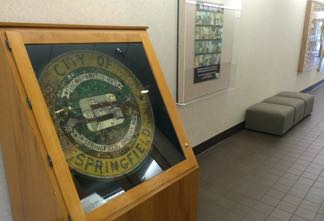
It’s hard to believe, but true, that the city seal displayed in City Hall in Springfield, Oregon, is made of trash hauled up from the sewer. Every one of its 4,200 pieces were salvaged in 1972 by then-employee Russell Ziolkowski when he helped the city jet clean its sewer system for the very first time.
The way I figure it, most of the stuff was flushed down someone’s toilet — on purpose or by accident.
It’s a little over three feet in diameter and weighs 70 pounds. Look closely to see the salvaged “junk.”
There’s a gold nugget, diamond pin, tiny revolver, padlock, a real tooth (and false teeth, too), hundreds of marbles, a 1942 dog tag, military pins, safety pins, fuses, buttons of all sorts, rings, a spoon, bracelet, fountain pen, coins, tweezers, a rifle bullet casing, wristwatch. . . and the list goes on and on.
It’s not the official seal, but a mosaic replica, but it was the only one I saw when I visited.
City Hall is at 225 Fifth Street, a couple of blocks off of Business Highway 126. The seal is on the second floor, along with most everything else.
By Chuck Woodbury
I survived my visit to the meat-eating plants along the Oregon coast just north of Florence. It turns out, these carnivores prefer insects to humans.
The plants occupy an area about half the size of a basketball court alongside U.S. 101. A short trail — maybe 1/10th of a mile, leads into the plants, and then a boardwalk extends right over them. They don’t look very special, but you can definitely see how they got the nickname “cobra lilies.” Their real name is Darlingtontonia californica.
I won’t go into much detail, but, basically, unsuspecting insects fly inside the plants looking for nectar. Bad move! Once inside, they get confused by transparent areas that look like exits, which, in reality, descend into a pool of water inside the stalk. The creatures were absolutely right about heading towards an exit —one to the insect hereafter!
To be technical, the plants don’t actually eat the bugs, in the way we eat. What happens is that bacteria in the water inside the plants decompose the insect into nitrogen that is then absorbed into the plant. To a cobra lily that’s good eating!
If you’re driving along U.S. 101, watch for signs to Darlingtonia State Natural Site a few miles out of Florence. There’s a picnic area there, so you can eat right along with the plants. Admission is free.
By Greg Illes “NO SIGNAL” — the words that are the bane of an RVer’s life. Without a connection, there’s no way to talk to friends and family far away. There’s no way to get news, weather, or your checkbook balance. Perhaps worst of all, there’s no way to call for emergency help.
Most of us now consider the Internet, and cell phone service, as simply a way of life, right up there with clean water and winter heat. But an RVer is not always within easy reach of cable or 3G/4G. In a suburban environment, it’s usually no big deal. We pay a bit more for data on the road (okay, maybe a lot more), but at least we’re connected. But for boondockers and other folks who wander out into the “great unknown”, having no signal is far more common than having a good connection.
We personally struggled with this for years. As dedicated boondockers (in fact, nearly fanatic), we’ve tried boosters, antennas, satellite phones — any possible method to achieve connection from the wide open spaces. All we got was frustration.
Most importantly, we need to couple the “want to have” and “nice to have” priorities, with the “Must Have” need to be able to deal with an emergency. Think medical, mechanical breakdown, stranding weather, etc.
We needed a robust, reliable method of communication, that would work from anywhere we traveled, allow at least basic messaging, and provide for emergency messaging as well.
And we found it. It’s called the InReach, and it’s made by Delorme (recently acquired by Garmin).
What It Is and Is Not
The InReach is a combination unit. It has a GPS “engine” and a satellite communication protocol, wrapped into a portable unit with an LCD user screen and some simple pushbuttons. It allows GPS tracking, satellite messaging, and SOS signaling and alerting, plus some other lesser features.
It won’t accept message attachments, and messages are limited to 160 characters. You can get weather reports, but you can’t get news or anything like a web page. Think “texting”.
Why It Works
The InReach has key features and characteristics that make it superbly suited to our needs.
•Satellite connection: InReach uses satellites to get connected. Such a connection can be achieved from anywhere on the planet. Mountains, deserts, oceans, are all covered.
•Iridium LEO Network: The LEO network (Low Earth Orbit) provides satellite coverage without having to “aim” the device at a geostationary satellite. This allows global connection, without needing a southern sky view.
•SOS and GPS coordinates: Like the Spot, InReach provides emergency location and notification data to rescuers.
•Text and Email: InReach also allows “ordinary” messages to be sent, and received. The limit is only 140 characters, but that turns out to be plenty for basic communication with friends and family.
•Weather: InReach provides a 3-day weather forecast on demand.
•Battery Lif: A full day’s hike and messaging uses less than 10 percent of the rechargeable battery.
•Incoming Messaging: Friends and Family can initiate messages to the InReach user. Using the Delorme website or a user-specific email address, anybody can send us a message any time, even if we did not send them one first.
Cost of the actual unit is about $300. (check at Amazon for specific prices) The connection services come in a variety of choices; ours is the Recreational Plan — $35 a month for occasional use, or $25 a month for annual contract. We choose the annual contract which includes 40 text messages a month, after which there’s a 50 cent additional charge. A weather forecast costs one message.
Unlike the Spot, there is no emergency insurance included with a subscription. However, it’s our feeling that with the improved communication capability we are far less likely to need such insurance. And if we do decide it’s a good idea, it can always be bought separately.
How We Use It
We use the InReach to message folks and let them know when we’re off-grid (so they won’t expect responses to emails or voicemails), and how we’re doing in terms of location, weather, exploration, etc. Sometimes, if we’ve been out of touch for many days, we’ll use it just to say “Hi, we’re fine.” Although there is the capability to use pre-recorded messages, we rarely do it. The InReach has a Bluetooth connection to my smart phone, and I type original messages very easily this way. The ‘canned’ messages are most useful when using the InReach’s more limited keypad.
We take it with us on any and all vehicle or foot explorations, both to record our tracks, and also if we need the SOS feature.
As far as the SOS feature, we’ve never used it (and hope never to have to). It would only be applicable if we had a medical emergency or if we could not find a friend to help us get a broken-down vehicle fixed or extracted (unlikely). But the SOS feature provides great peace-of-mind, especially with our experience of how reliable the InReach operation has been.
The messaging interface even has a feature where we can post our current location to Facebook, something we use now and then to share our experiences.
As part of the subscription service, Delorme also stores and displays our tracking points on a pannable, zoomable map. While tracking, points are captured every 10 minutes, with no limit on points stored. The map below will give you an idea. Or see our personal map (photo) and here.
Previous Stuff that Did Not Work (and why)
•3G/4G: Firstly, let’s be clear on 3G/4G (cell phone service). There are many vast tracts of land in the American West, and the Canadian and Alaskan North, where not a shred of signal exists. It’s not a matter of using a high-gain antenna or booster or getting to a hilltop. There is simply nothing there. For tens or even hundreds of miles at times.
•WIFI: WiFi is strictly a locally-provided linkage, usually from a commercial facility like a restaurant or RV Park or library. Its quality is variable to very poor. Of all the paid/included/public WiFi we’ve ever found, I’d estimate perhaps 5 percent of it was useful. And in any case, when there’s nobody around (remote boondocking), there’s definitely no WiFi.
Spot: We researched the Spot (another satellite tracker/messenger), and found it lacking. First, it’s on Glonass, a less-reliable satellite constellation. There were many, many reports/reviews of missed messages and missed tracking points. Secondly, it had no provisions for “new” messages, only a few pre-recorded ones. And thirdly, it had no method to receive messages at all.
Satellite Phone: We tried a satellite phone on the Inmarsat satellite, which is a geostationary unit (fixed in space). It required a clear view to the southern sky, which is surprisingly unreliable especially in hilly or mountainous terrain. Even normal forests would block the signal. The farther north we went, the worse it got. I consider the service unusable (for me) anywhere north of the 50th parallel or so. Moreover, even with a good signal, the phone’s antenna needed to be pointed within a few degrees of the satellite’s position, and normal body movement during a call would drop the signal. Using the satellite phone for “I’m okay” messages costs $6 per minute, which can add quickly to the required monthly activation cost (about $35). More importantly, using the satellite phone for emergency/SOS messaging requires calling a specific phone number based on current location — a difficult action to coordinate, especially under emergency conditions.
We never tried a LEO (Iridium or Glonass) phone. This would have solved the connection problems, but still left the cost and SOS issues to deal with.
Latest and Greatest
Our InReach is an earlier version, without the GPS mapping of current models. However, the linkage to my cell phone, via Earthmate, makes this moot. For example, it’s really easy to compose a message on my cell phone’s keyboard; by comparison, creating that same message on the scroll/select InReach screen is painfully slow. My cell phone also provides a large, hi-res map via Earthmate, much better a navigation tool than the tiny screen on the InReach.
The only downside to the pairing of the cell phone is that my phone’s battery doesn’t last anywhere near as long as the InReach. For more than day-hikes, a solar charger would be a must.
The Future
We won’t travel without this thing. It’s handy, easy to use, and provides great peace of mind at a reasonable cost. Now, in late 2016, as far as I know, the InReach is the only device available with such capabilities. But with Garmin’s acquisition of Delorme, it’s not hard to imagine a future with a host of Garmin GPS units capable of satellite up-linking. Pretty exciting.
Greg Illes is a retired systems engineer who loves thinking up RV upgrades and modifications. When he’s not working on his motorhome, he’s traveling in it. You can follow his blog at www.divver-city.com/blog.
The Desert National Wildlife Refuge is not somewhere you go to stay in a full hook-up RV resort or to visit Nevada’s famed casinos.
More likely you’ll be slathering on sun block and scanning the horizon for a bit of shade. But the oasis at the refuge headquarters at Corn Springs is a welcome splash of green grass, green trees, and shade surrounded on all sides by desert scrub and creosote.
An amazing number of migratory and song birds visit this refuge to take advantage of the copious water flow from the year round spring, plentiful food supplies, and a safe nesting habitat. Observation is best in early morning and late afternoon during the most active feeding times for both birds and wildlife.
As many as 50 species of birds have been counted here in a single morning, flitting about in the large oak trees, cottonwood, willow, and fruit trees planted by earlier residents that flourish around the spring.
In the back country of this huge 2,200 square mile refuge — the largest in the lower 48 states — live the greatest number of bighorn sheep outside of Alaska, as well as mountain lions, eagles, coyotes, and kit foxes. You wouldn’t notice the refuge unless you traveled the four miles of dirt road to the visitor center, one of the BLM’s few, which has maps, bird lists, restrooms, and a wonderful nature trail leading around the ponds fed by the spring.
Boondocking with views of looming Mt. Charleston is permitted on the open land surrounding the visitor center.
For the adventurous, the Mormon Well Road, suitable for four-wheel drive or high clearance two-wheel drive vehicles, starts from Highway 95 and terminates on Highway 93 near State Route 168. Typical travel time from Las Vegas is about four hours total.
Take I-95 north from Las Vegas 22 miles to the Desert National Wildlife Refuge sign and turn right four miles to the visitor center.
You can find Bob Difley’s RVing e-books on Amazon Kindle
Fall has to be one of our favorite times of the year. Daytime nice, nighttime cool air. Fall leaves. Burger King coupon book specials!
That’s right, come October, Burger King rolls out its coupon books in support of high school students who want to get more education. The company has a little foundation that they support to encourage learning, and to help support it, they do a sort of fund drive by printing up coupon books full of “freebies,” like french fries, ice cream cones, chocolate chip cookies, etc. All in all, a half-dozen freebies.
The coupon books cost $1 and that money is passed along to their scholarship program. Of course, it’s a great deal for the students, and a great deal (if you don’t count the calories) for the buyer. Now here’s the gig — apparently not every Burger King restaurant is participating. We were a bit dismayed to see that the B-Kings in the Quartzsite, Ariz., area are apparently NOT participating this year, but we did put up the son-in-law to snag us a few booklets up in the Pacific Northwest.
Hurry on this one — the outfit usually shuts down the promotion at the end of October.
By Chris Dougherty Chris Dougherty is a certified RV technician. Here is a letter he received from a reader while he was serving as RVtravel.com’s technical editor.
Dear Chris,
I own a 2004 Jayco 27DS motorhome. The side entrance door is slightly bent. The lower part of the door where it opens is a little less than an inch from closing. There is no sound of wind whistling when I drive. The door opens toward the back of the motorhome.
My question is: Can I repair this somehow by bending the door back in place? When it is cold, there is a small draft coming from the space where the door does not meet the frame. The frame appears to be square. —Roy Christensen
Dear Roy,
The answer to your question is “yes.” I have seen RV doors get tweaked and not seal properly, and if the one corner is out and the rest of the door and jamb are true, then carefully bending it back is OK. Another option is to replace the weather strip with something more substantial to take up the space.
By Chuck Woodbury
The Earth threw up lava in the Cascades near present-day Sisters, Ore., and today, scenic Highway 242 passes through a swath of the 65-square mile, surreal landscape. At the summit, a paved walking trail meanders through a half-mile of the flow. If you have never seen a lava flow, be prepared to be impressed!
Mt. Jefferson, one of the most beautiful Cascade volcanoes.
This flow burst forth violently from Earth a mere 1,800 years ago — “yesterday” in geologic time. Lichen now grows on the lava, slowly forming the building block for more significant vegetation. Return in 50,000 years and the scene will look pretty much like everywhere else in Oregon.
THE FIRST ROUTE through here was an 1860 wagon route. Today’s paved, two-lane highway travels along much the same path. Signs at both ends of Highway 242 warn that vehicles and vehicle combinations longer than 35 feet are prohibited. Personally, I think anything longer than 28 feet is too long. The road is typically closed November to July due to snow.
The Dee Wright observatory.
The Dee Wright observatory at the summit is made of lava. It was built by the Civilian Conservation Corps; workers named it after their foreman who had died a year earlier. An easy walk leads to the observatory, where the magnificent view reveals a panorama of lava, in some directions as far as the eye can see, as well as stunning views of nearby mountains and volcanoes, including Mount Jefferson and two of the Three Sisters.
There is no admission fee. Don’t miss this if your travels take you to Bend or Eugene, where a drive to the pass makes for an easy day trip. Stop in Sisters for lunch and to visit the many tourist shops.
We use cookies to ensure that we give you the best experience on our website. By continuing to use our site, you consent to accepting cookies. We NEVER have or will sell reader's data. For more info, please see our privacy policy page.


 This is the roof of my motorhome the day we were leaving Eugene. We were parked under a tree for nine days. I figured I’d check the roof before we left. Wow! Yup, there were a lot of leaves. I guess I could have just left them there and let them blow off. I decided to sweep.
 We’re in Medford, Oregon, now. We’ll stay a week. When it stops raining we’ll head up to Crater Lake. It’s about a 90-minutes drive. Tomorrow we’re heading to the nearby Oregon Vortex, where things are weird. For example, water runs uphill. I think it’s all trickery. The reason I say that is I saw the same thing as a kid at Knott’s Berry Farm. There’s no Vortex in Anaheim, I’m pretty sure of that. Gail has never been to a Vortex before. So she’s excited. I’ll take a picture of her standing sideways and show it to you later.
 Twin giants in Medford
 Until about two months ago, I lived for about 11 years in a small condo in Edmonds, Washington. It was old, built in the 1960s as apartments, then converted to condos about 25 years ago. There are 77 units in the complex. About five years ago, we were all assessed $8,500 for necessary repairs to the building. Then about six months ago, we had to pay another $3,500. Our condo dues of about $400 a month came up short.


 Frances died in 1992. Today, the Frances O’Brien Memorial Library is open 11-3, six days a week, with an all-volunteer staff. It still operates on the honor system. “If someone doesn’t return a book for a year or two we give them a call,” said volunteer librarian Mary Jo Carroll. But there are no fines.

 UPDATE 10:15 a.m. Saturday:


 Got an RV parked at your house? Lock your doors! That’s the admonition from Eugene, Ore., police after a rash of RV burglaries and “uninvited guests.” Several RVs have been burgled, and in some cases the crooks have lived in the rigs — sometimes for days. All the robbed RVs had unlocked doors.
 Don’t try to outrace the 1972 Winnebago Brave motorhome modified by a Canadian company. It has a brand-new, smoking-hot 900 horsepower engine, a far cry from the gutless wonders of the era. The outside looks pretty much like any other 1972 model. But the inside? You have to see it!
 Winter Differently This Year!


 Organize your bath with a shower caddy
 Help for emptying tanks on a slope
 Temperature gun is ‘essential equipment’ for many RVers!
 Lava as far as the eye can see
 Endorsed by Roger Marble of RVtireSafety.com!
 Snag some Burger King loot — cheap!


 Avoid moisture damage to your RV


 Camco Wheel Chocks. Two Pack
 Strengthen your hands, fingers and forearms


 Forget messing around with flares.
 From Paul and Debi Pitzer (retired), Rendon, TX
 Tired of stuff moving around in your RV fridge after a day of driving? Maybe a carton of milk has fallen out on the floor one too many times? Here’s the solution. Camco’s RV Double Refrigerator Bar is designed to keep order in your RV fridge during travel. It’s spring loaded to keep items in place. The bar extends from 16″ to 28″. And the good part is the price tag: about $5! (The RVtravel.com staff uses a pair of these in its RV!) Learn more or order.
 Fix it in Foil! Tasty Recipes. Easy cleanup!


 Every RVer with 30-amp service should have this on board
 It’s hard to believe that an electric space heater could use a mere 200 watts — the same as a couple of light bulbs —a fraction of other space heaters. And this one really works! It’s meant to heat a nearby person, not a room. Put it on your desk or at your feet. It’s perfect for the RVer who’s “always cold.” For about $17, this is a winner. Click the video by RVtravel.com editor Chuck Woodbury.
 Cooluli introduces portable six-can cooler/warmer
  Easy way to level your RV!
 Get ready for winter
 Stupid Statements of Yesteryear
  Prevent hose crimping and strain

 Keep rodents out of your RV!
 Help stabilize

 By Chuck Woodbury
 The way I figure it, most of the stuff was flushed down someone’s toilet — on purpose or by accident.
  There’s a gold nugget, diamond pin, tiny revolver, padlock, a real tooth (and false teeth, too), hundreds of marbles, a 1942 dog tag, military pins, safety pins, fuses, buttons of all sorts, rings, a spoon, bracelet, fountain pen, coins, tweezers, a rifle bullet casing, wristwatch. . . and the list goes on and on.
 The plants occupy an area about half the size of a basketball court alongside U.S. 101. A short trail — maybe 1/10th of a mile, leads into the plants, and then a boardwalk extends right over them. They don’t look very special, but you can definitely see how they got the nickname “cobra lilies.” Their real name is Darlingtontonia californica.
 I won’t go into much detail, but, basically, unsuspecting insects fly inside the plants looking for nectar. Bad move! Once inside, they get confused by transparent areas that look like exits, which, in reality, descend into a pool of water inside the stalk. The creatures were absolutely right about heading towards an exit —one to the insect hereafter!
  To be technical, the plants don’t actually eat the bugs, in the way we eat. What happens is that bacteria in the water inside the plants decompose the insect into nitrogen that is then absorbed into the plant. To a cobra lily that’s good eating!
 Most of us now consider the Internet, and cell phone service, as simply a way of life, right up there with clean water and winter heat. But an RVer is not always within easy reach of cable or 3G/4G. In a suburban environment, it’s usually no big deal. We pay a bit more for data on the road (okay, maybe a lot more), but at least we’re connected. But for boondockers and other folks who wander out into the “great unknown”, having no signal is far more common than having a good connection.
 An amazing number of migratory and song birds visit this refuge to take advantage of the copious water flow from the year round spring, plentiful food supplies, and a safe nesting habitat. Observation is best in early morning and late afternoon during the most active feeding times for both birds and wildlife.
 That’s right, come October, Burger King rolls out its coupon books in support of high school students who want to get more education. The company has a little foundation that they support to encourage learning, and to help support it, they do a sort of fund drive by printing up coupon books full of “freebies,” like french fries, ice cream cones, chocolate chip cookies, etc. All in all, a half-dozen freebies.

