


Fort Loudoun is the featured ghosted place for this month’s edition of Ghost Town Trails. I chose Fort Loudoun as a regular RVtravel.com reader mentioned that while he found the ghost towns I write about interesting, they are mostly out West. These are far from his home and even if he found a reason to travel that far, the conditions of the roads would not allow him to travel the final leg to reach the destination with his diesel pusher. Therefore, I decided to start including more easily accessed “abandoned” places east of the Mississippi. Neal, this one is for you and the many other RVers who live in the Central and Eastern time zones.
History
Fort Loudoun, a British fort constructed between 1756 and 1757 in what is now Monroe County, Tennessee, played a crucial role in British efforts to gain Cherokee support during the French and Indian War. Named after the Earl of Loudoun, the fort was strategically located west of the Appalachian Mountains and was designed by John William Gerard de Brahm, with construction supervised by Captain Raymond Demeré.
The design and construction of Fort Loudoun were not without challenges, including disagreements between Captain Demeré and engineer de Brahm over the fort’s location and design. Ultimately, a compromise was reached, and construction began in October 1756. The fort’s design was elaborate, featuring diamond-shaped walls with bastions at the corners and a complex of buildings inside.
Initially, relations between the fort’s garrison and the local Cherokee were positive. However, tensions arose in 1758 due to conflicts between Cherokee fighters and Anglo-American settlers in neighboring regions. The situation escalated when 16 Cherokee chiefs, held hostage at Fort Prince George, were killed by the garrison. In retaliation, the Cherokee laid siege to Fort Loudoun in March 1760. Despite holding out for several months, dwindling supplies forced the fort’s surrender in August 1760. Hostile Cherokees attacked the retreating garrison, resulting in casualties and captives.
Subsequently, James Grant led a British expedition against Cherokee settlements, leading to peace negotiations and a peace expedition to the Overhill country by Henry Timberlake. In modern times, efforts to preserve and study Fort Loudoun have been ongoing. Excavations conducted by organizations like the Works Progress Administration in the 1930s and later by the Fort Loudoun Association and Tennessee Division of Archaeology in the 1970s and 1980s provided valuable insights. The fort was designated as a National Historic Landmark in 1965 and reconstructed above the water levels of Tellico Lake. Today, it serves as the focal point of Fort Loudoun State Historic Park.

Our visit
While there are many ghost towns from the mid to late 1800s in the Western states, where my wife and I regularly explore, the Western states have no historical sites from the 1700s, let alone sites involving the French and Indian War. Therefore, when we were recently in Tennessee to speak at an RV Show, we jumped at the chance to visit such a historic site.
Upon arriving, we started at the visitors’ center. It was a good thing, too, as it was a long time ago when I “learned” about the French and Indian War at school. After studying the exhibits and watching a short video in the theater, I realized I hadn’t remembered much, if anything, of what I was taught in school.
With a fresh understanding of the conflict, we headed to the fort, which is about a 250-yard walk that ascends a knoll as you approach the fort. Upon arriving at the sally port, we passed through the palisades and were greeted with a view of the fort buildings descending the slope below, the British flag waving in the breeze above us and a commanding view of Lake Tellico (impounded Tennessee River) beyond the far walls of the fort.

Since we were the only ones there, it helped to visualize what fort life must have been like over 250 years ago. As we strolled the buildings, I was impressed at the level of detail that was used in the reconstruction. Square cut nails held the floorboards in places, walls of roughhewn logs still displaying the broad axe marks used to shape them along with door and window hardware all being hand-forged by a blacksmith. As we walked through the barracks and the rows of bunks (soldiers slept two to a bed) I could only begin to imagine what it would have been like to be stationed out here—hundreds of miles from any form of civilization.

The commander’s quarters didn’t offer much more in the way of luxury other than having a good view of the river. Many elevated walkways exist along the palisades, which contain gunports. If attacked, the soldiers would have stood on the walkways extending the barrels of their muskets through the gunports allowing them to fire on the enemy without exposing themselves to return fire. The gunports were high enough to prevent the enemy from using them against the soldiers if they were to reach the palisade walls. From the walkways, I ventured onto the bastions, which are located on all four corners of the fort. Cannons were located on the bastions and positioned to defend against attack from any direction.
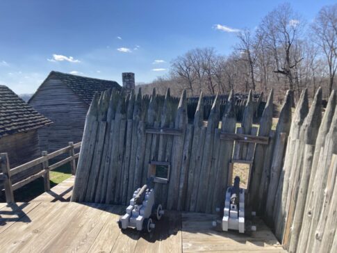
Our final stops were the blacksmith shop and the bake oven, both of which appeared operational for the enactments that take place at the fort. Upon arriving back at the visitors’ center, I took one more look at the display of muskets. All appeared operational, including flint in their flintlocks. As we exited, I inquired with the ranger on duty about the muskets and he confirmed they are operational and fired often for school groups and reenactments. Boy, would I like to return and see a volley of fire from those guns!
Getting there
Fort Loudoun is located about 30 miles south of Knoxville, Tennessee.
Driving instructions:
From the intersection of Hwy 411 and 360 in Vonore, TN, take Hwy 360 south for approximately 9/10ths of a mile to Fort Loudoun Road. Turn left on Fort Loudoun Road, arriving at the visitors’ center in just over a mile.
As you enter the main parking lot you will find a long row of parking for buses and RVs along the right (south) curb.
Entry to the park is free.
Fort Loudoun State Historic Park
338 Fort Loudoun Road
Vonore, Tennessee 37885
Click here for more information.
Camping
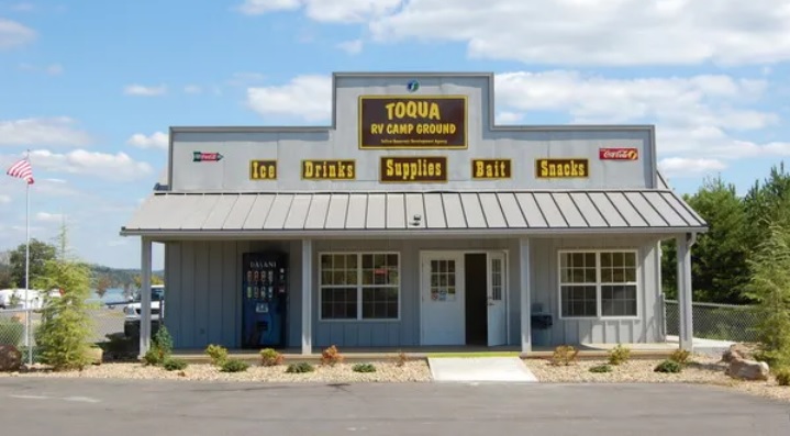
There is no campground in the park itself. The nearest campground is Toqua Campground just south of Fort Loudoun State Historic Park featuring spacious grass full-hookup RV sites. Many of the sites are on the lakefront.
Previous Ghost Town Trails entries you might enjoy:
- Bickel Camp: Explore this treasure trove of relics in California
- Burro Schmidt Tunnel—A strange obsession featured by Ripley’s Believe It or Not! – California
- Ruby, AZ – Southern Arizona’s ‘best-preserved’ ghost town
- Finding the Christmas spirit in Poinsettia Mine, Nevada
- Dublin Gulch, California – Cave dwellers of the 20th century
- Berlin, Nevada: Ghost town with ancient marine creatures
- Rhyolite, Nevada – An easy ghost town for RVers to visit
- Deadwood Mine, Idaho and its mysterious vault
- Eureka, Utah – Visit easily accessible old mining town
- Silver City, Utah – Heartbreak and thanksgiving
- Fort Macomb, LA – Does this picturesque Civil War-are fort look familiar
- Castle Dome City, Arizona – Perfect for nearby snowbirds
- Fort Selkirk, Yukon Territory
- Coolidge, MT – ‘Montana’s Mystery Camp‘
- Ballarat, California
- Greenhorn, OR – Oregon’s smallest incorporated city
- Elkhorn, Montana – The cover photo of popular “Ghost Towns of the West” book
- Tunnel Camp, Nevada
- Bonnie Claire, Nevada
- Tumco, California
- Mackay’s Mine Hill, Mackay, Idaho
##RVT1150

Check out Fort Mackinaw at the northern tip of Michigan’s lower peninsula or the fort on Mackinaw Island.
I have gone by that area dozens of times on I-75. Never realized it was there, always heading for some other destination. I will have to check it out the next time we are in the region. Thanks for the article and to Neal for pointing it out.
Thank you, Dave (and Cheri)! 🙂 To my embarrassment I have never been there. I will go as soon as I can to fix that. Thank you for the review and accompanying pictures! 🙂 Safe travels, and happy Easter! 🙂