


A tractor-trailer driver’s apparent overreliance on GPS navigation led to the closure of Snake Creek Road in Great Basin National Park. Some speculate the driver was attempting to bypass a weigh station, while others believe he was seeking a shortcut across Nevada’s Snake Mountain Range. Whatever the reason, the incident highlights yet another costly misadventure caused by misguided GPS directions.
GPS misleads—Do not blindly trust them!
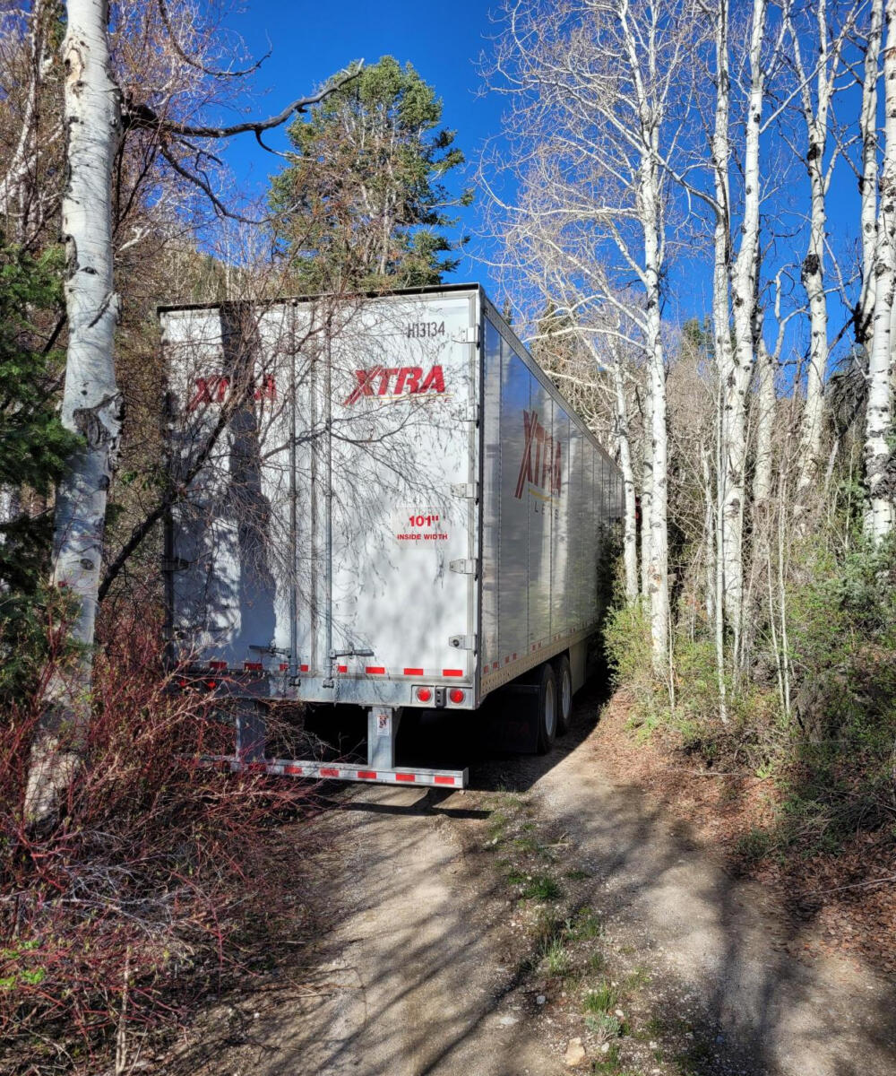
Snake Creek Road is closed “until further notice,” as the misguided tractor-trailer driver stuck his rig like a cork in a bottle just a mile from the end of the road. A Park Service post asks, “Please avoid the area, as crews are working to safely remove the truck with a minimum of damage to the road and natural resources.”
Park workers also post a principle that can be used ANYWHERE: “Do not blindly trust your GPS navigation system!” Specific to Great Basin, its roads are narrow, winding, and not designed for commercial vehicle traffic. All roads entering the park dead-end inside the park and cannot be used for through traffic across the Snake Range.
MORE POSTS ON GPS
• RV boo-boos: To trust or not to trust the GPS?
• NY bill would require GPS to display bridge and tunnel heights
• Poll: Has your GPS ever misled you? (with tons of comments!)
• Just touching your GPS when driving in Alabama could get you in trouble
• Be careful about that back-road bypass; and think about which GPS to trust
RVT1210

If he had spent the money for a truck, or rv specific GPS, he wouldn’t be in this situation. I used a Rand McNally when I drove a truck, and I continue to use it when I pull my rv.
Be careful buying Rand McNally GPS products. By their terms, they can discontinue map update support after 24 months FROM PRODUCT INTRODUCTION. You could buy 2 years after they introduced the product and never get any updates.
This is exactly what happened to thousands of RVers with Rand systems installed in their RVs…mine included. Yes, one can still use it, but it will never be updated.
They’ll never get a dime from me again.
Exactly Dale, I had to buy a new GPS cause my rand McNally was so old it wouldn’t update anymore but I bought a truck specific one, also I double check my route with my map book because that’s what I did when I drove truck just to be sure the GPS is correct, a lot of new drivers don’t know what a map book is.
Thank you for the news and admonition to not unreservedly trust GPS devices, Russ and Tina! Our RV GPS ostensibly is largely mistake-proof. That is, the RV’s dimensions are incorporated along with weight in addition preferences, such as avoid dirt roads. But, DW simultaneously runs the Waze and Google Maps applications, and even resorts to Google Earth sometimes. So far only one minor disaster, which was the only road to our destination. Our solution was to change the destination; problem fixed. 😉 Have a great day and safe travels!
GPS does a decent job telling you how to get somewhere but it misses the mark on what it will take for you to get there. We try to avoid roads that are chunked out dish breakers whether it be I-40 east in New Mexico, I-70 Mountain Corridor or I-17 south out of Flagstaff. The condition of our interstates in some places is appalling yet the taxes still get collected and the politicians get fatter.
“We try to avoid roads that are chunked out dish breakers whether it be I-40 east in New Mexico, I-70 Mountain Corridor or I-17 south out of Flagstaff.”
I wish there was an app or website that rated road quality. Is there one?
Kinda like the semi we met on million dollar highway glad I was on the inside and in my towed or we wouldn’t have made it
If that picture is correct…a person’s EYES are enough to tell you the GPS is steering you wrong! What ever happened to common sense? We all rely on machines way too much and forget that WE have a brain too, and should use it!
Makes me wonder if he spoke English…just say’n.
I was heading to a destination, traveling down the road and over a bridge,
the GPS telling me to take the next right and about 1/4 mile later telling me
to turn right again and “navigate off road.” The screen showing a dotted line
crossing the river.
Garmin bought our “Magellan” (competition) without incorporating the more accurate device. We traveled 15,000 miles last winter and the RV Garmin made mistakes many times. DW gave parallel directions on her phone (google maps) often and we grew to not trust the Garmin. I phoned them to complain, was asked to document the errors so they could correct them. 🤷♂️ I told them to send me a refund plus $30 an hour for my time.
I’ve had my phone tell me to turn right while showing an arrow pointing left. Luckily I know which way to go when it does that but some day I might not.
We had an early Garmin that I removed from the car when we went to visit Alcatraz Island. While there, I requested directions home. It showed a line straight across the water to Pier 39 and said: “Please drive the highlighted route…”
I just drove through Texas and I swear my GPS was trying to get me lost! I drove down more “Farm to Market” roads, made more left turns on x for 3 miles, right turn on x for 12 miles…I thought I would go crazy! I double checked to make sure I hadn’t set it avoid freeway! It was beautiful country…for the most part but so desolate. I actually ran two GPSs at a point, phone and GPS, just to make sure it wasn’t sending me to someplace I didn’t want to go. I was trying to get to a USACE (COE) park. Finally got there, tired, stressed and ready rest.